September
23, 2022 -- One More Time
Two realizations helped us plan our day. The
first was that it appeared this would be the last "nice" day for a
stretch, the weather turning cold and rainy tomorrow. And we had one
more chance for a Mama Cow's ice cream before they closed for the
season. Now we're not big ice cream eaters, but this small but
special "shop" in the small town of Chatham has truly caught our
fancy. The place itself, the building, the corn crib, the pastoral
backdrop, the owner and workers, are wonderful. But it's the super
premium rich ice cream, made in Madison, Wisconsin, by the Chocolate
Shoppe that gets us there, us and a crowd of others! This is a very
popular stop. As the information on their paper bowls
states: "Nutrition? Don't even ask. ... it has Gobs of rich Wisconsin cream,
tons of real ingredients for boat-loads of luscious flavors.
That means it's not low-fat, low-calorie or low anything, and that's
why everyone Loves it. If you want nutrition, eat carrots." And we
do, of course, but we also eat their ice cream!
But we needed to do something first to make
it a real treat to look forward to. So we spent the morning on
outdoor projects we wanted to get done before the weather turned
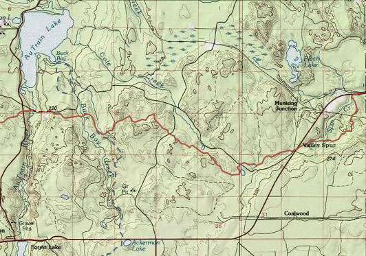
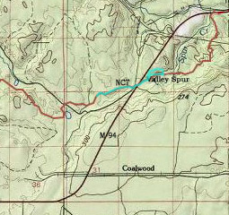
then after lunch headed north for a hike. There are a number of
trail options but we decided to go to Valley Spur (west of
Munising), cross the road and walk north on that section of the
North Country Trail. This was a trail we knew as we had worked on
clearing and marking it some years ago. It's a real nice single
track through the woods, and being a NCT trail,
it winds over-around-up-down in an enjoyable and energizing way. It was a nicely cool, mostly
cloudy but no rain kind of day. Very pleasant walking.
Since we "knew" the trail we were surprised
to very soon find ourselves on a route different that what we
remembered. This was obviously a fairly new and extensive reroute,
and a lot of work had gone into it. I was a little disappointed
because there was a section missing that I liked. But we also
remembered the low swampy area that this reroute avoided so we
understood and appreciated the work done. Soon though we were on
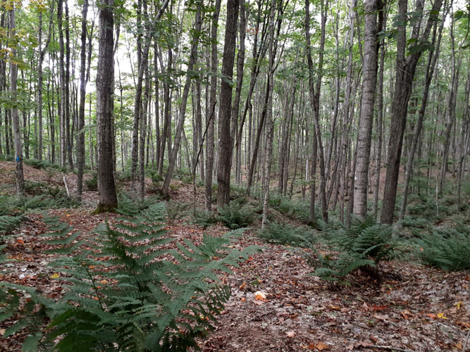
familiar ground, enjoying the variations in the woods, and the
magical sections full of large ferns and low spreading yews. This is
pretty much an all-woods trail with few obvious "landmarks" but we
happen to love walking in the woods and had a rough idea of where we
might be based on a couple of road and two-track crossings.
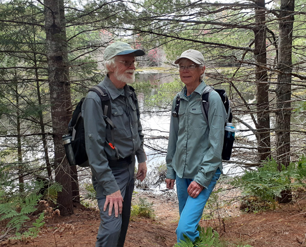
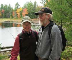 There
is one special landmark though, well known to hikers of this
section of the trail, a sudden change from the trees - two ponds,
one on either side of the trail, called (not surprising) The Ponds,
with a small bridge where the two try to meet. It was on this trail
almost twenty years ago that friends Lynn and Lon Emerick
introduced us to the North Country Trail by inviting us to go for a
walk with them. Lynn took a photo of us on the bridge at the Ponds.
The vegetation around the bridge has now grown up quite a bit but below is
today's picture just a few yards away. A little less color, a few
more wrinkles, different caps, but we're still hiking! There
is one special landmark though, well known to hikers of this
section of the trail, a sudden change from the trees - two ponds,
one on either side of the trail, called (not surprising) The Ponds,
with a small bridge where the two try to meet. It was on this trail
almost twenty years ago that friends Lynn and Lon Emerick
introduced us to the North Country Trail by inviting us to go for a
walk with them. Lynn took a photo of us on the bridge at the Ponds.
The vegetation around the bridge has now grown up quite a bit but below is
today's picture just a few yards away. A little less color, a few
more wrinkles, different caps, but we're still hiking!
It was a real nice four hours on the trail
(we took sandwiches to sustain us) and we once again made it back
and to Mama Cow's in plenty of time for our last ice cream treat of
the year. But it certainly won't be our last hike!
December 3, 2021 - Finding Forestville
Trailhead
A day similar to our Seney walk Monday
(mostly cloudy, mild wind, about 32 deg.) found us in Marquette and
ready to stretch our legs after the 2 hr drive. We took care of our
other commitments and headed out into the confusing pattern of
trails and roads among which was to be found the Forestville
Trailhead, a main hub on the Noquemanon trail network. And, we
hoped, the North Country Trail, having decided to walk from
Forestville back to where we had stopped last trip, then northwest
where we hadn't walked yet. The Noquemanon map is very nice but
comes up a bit short on finesse when it comes to fine points of
exactly where a trail is, especially the NCT when it intersects
their trails. On the other end the NCT maps are precise and clear,
showing most roads plus elevation (which helps a lot in this
variable terrain) but only a little of the Noquemanon trails. There
is more information online though. Not to complain in any way; this area is a
complicated mass of criss-crossing trails and roads, many with no
names or designation, and both organizations do an amazing job with
their trails. Steve had an idea where to go so off we went, hoping
for signs for both getting to the Trailhead and finding the NCT.
Not to worry. It was a lot of turns and
corners on un-named dirt roads but Noquemanon had signs at every
corner. We made it there in good time and it was indeed a mega
trailhead compared to the usual little pull-offs with a sign. But
the focus and reason to be of the Forestville Trailhead is the cross
country ski and biking trails complex, with ample parking, large
building, lights, constructs, equipment, outhouses, etc, and signs
saying the area was for members and guests only. We decided we must
be a guest and found a spot out of the way to park the car. There
was only one other vehicle plus someone on an ATV plowing so there
was plenty of room. And though there was only maybe 4-6" of snow
with bare ground showing here and there it appeared they had groomed
the ski trails already! Sure enough, in came a skier (and a couple
of bikes were heading out when we returned). But there was room for
everyone and we headed on down the snow covered and very slippery
drive to the equally slippery road looking for the NCT, which by the
maps should be nearby. We hoped it would be easier walking on the
trail.
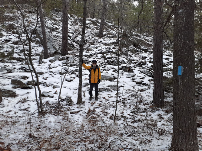
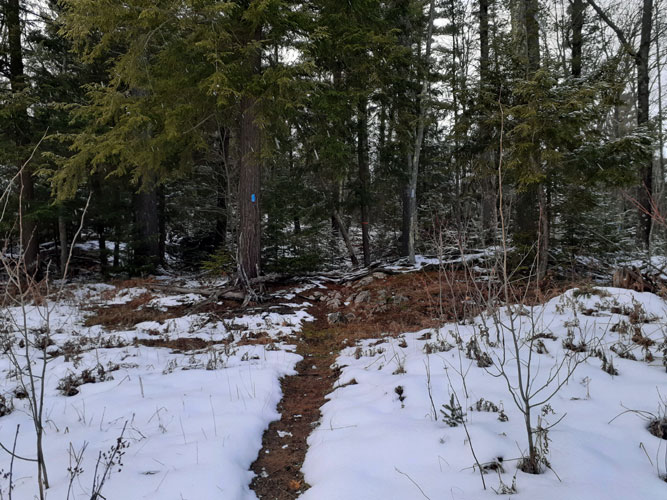
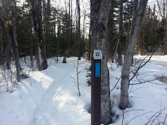
It wasn't far and I spied the friendly blue
rectangle of the NCT trail. It felt good to step off into the woods
and start following the very well and recently re-marked trail. Back
on then off a rutted snow covered dirt road then finally settling in
to walk another beautiful section of the NCT. Since this was a
continuation of the territory of our last walk we weren't surprised
to very soon encounter a hill of rock, with enough rocks and roots underfoot to slow
us down to very mindful walking.
 .
.
Up, over, down, through a beautiful section
of mixed woods, made a bit trickier walking with snow covering the
wet leaves but the temperature near the ground stayed in the sweet
spot of cold enough to not be too wet and warm enough to give
traction in the snow. There were also sections of bare (leaf
covered) ground and we relished what was likely (based on the
weather forecast) the last we'd see, and walk on, that for many
months. After about a half hour the trail heads fairly close to the
road and through some lower, flatter, no rock woods which gave some
relief. We tried to determine where we had turned about the last
trip but it's surprising how different a trail can look coming from
the opposite direction, and now mostly covered with snow. We guessed
at the spot but decided to continue on to the Big Rock. There were
some wet sections along some lower parts but easy enough to go
around. And though you could hear traffic on the nearby road it's a
nice part of the trail.
After about another half hour up, up the
trail went, and we went slowly, slowly, carefully choosing our steps
on the jagged rough snow and leaf covered rocks up onto the
wonderful rounded bare top with a grand view across nearby valleys
to other large rock outcroppings in the distance. But the last time
we were here the only trail markers had been older painted ones on the rocks at
your feet and now there were new blue aluminum trail markers on the
sparse but hardy small trees along the rock (great work by the trail
volunteers!). But this was indeed where we had been before and we
walked across on the rock-top trail to look down the even trickier
descent on the other side. Yes, we remembered that, too, and decided
this was a good spot to turn around and go back. It was definitely
cooler up on top and we were happy to make our way down and into the
warmer woods.
Back to near the Forestville Trailhead we
discovered where the NCT crossed the road and went along beside the
Trailhead complex (there was our car), coming out on the other side,
sharing or crossing ski and bike trails through what must be (based
on the tipped up picnic tables and fire-rings) the Forestville
Campground and through an obviously logged oak woods (must have been
beautiful before!). Crossing or following for a short distance
two-tracks and trails we left the Trailhead area. Going through some
light woods and heading up we came across a wide cleared expanse of
major power lines, going straight through hills, valleys, woods and
anything else, to the (recently demolished) power plant at Lake
Superior. One could not only see the Lake but Presque Isle as well.
The NCT does have its non-scenic times, but this section was
comparatively short and was a good contrast to the
rest. We really appreciated stepping back into a nice woods, leaving
the other trails, tracks and roads behind. The walking on this NW
side of Forestville Trailhead was much easier - no rocks.
We walked through a beautiful mature cedar
and hemlock woods high along a ridge and were surprised to look down
onto a delightful winding creek at the bottom. The surprisingly
swift running small water crossed over, under and through little
dams of downed branches and trees. Soon the trail made its way at an
angle down the slope to follow along beside this magical and musical
creek, deep in the shadows of the woods. The sound was equally as
wonderful as the view. We wanted to take a photo of this highlight
to share but it was too dark. On the other side of the little valley
the trail headed back up to follow through a beautiful hemlock
woods.
It was getting time to turn back so we
looked for a memorable spot to mark (in our minds) the turn-around
for a future continuation of our walk on this section of the NCT. Up
ahead was a clearing which turned out to be an old road. Across that
was a nice entrance back into the woods where we sat for a rest
snack before the return trip.
The sun came through the cloudy sky enough
to cheer the stop though rifle shots in the woods reminded us that
though the main firearm deer season was over there were still people
with guns in the woods, and we didn't want to be out there as the
sun went down. We did consider that maybe dog bells might be a good
idea this time of year. So we ate our cookies, crossed the old
two-track and headed back into the woods, down and across the
wonderful musical creek, up the other side and through the beautiful
hemlock and cedar woods.
Soon we saw the Forestville complex through
the logged woods and only 40 minutes since we left we were back at
our car. These two walks from the Trailhead, east and northwest,
showed how one really can't estimate how long a trail section might
take based on distance. The east walk with a lot of slippery rock
and ups and downs was about 3 miles out and back and took us 2
hours. The northwest part with relatively easy walking was about
half that distance on the map and only 40 minutes time. Thankfully,
our criteria isn't distance but enjoyment. And we had a very
enjoyable hike indeed.
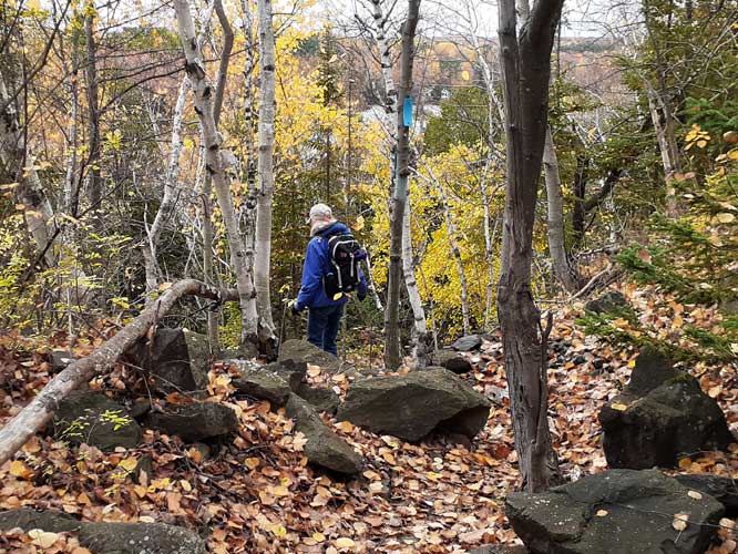
October 29, 2021
--
NCT - Noquemanon Marquette North Trails
This is a wonderful and popular trail system with wonderfully varied
terrain. An amazing layout of trails, roads, railroad, water through a
fairly narrow stretch of land north (and west) of Marquette shows what
can be done to happily accommodate varied interests. The many
non-motorized trails are maintained by the Noquemanon Trail Network. One
of the trails running through is the North Country Trail. Roughly
paralleling is a popular (mainly) biking trail, and along the Tourist
Park Reservoir is the 'EZPZ' route which seems to be a favorite of dog
walkers. Since the three trails often cross or come close to one another
it's easy to switch to another should you want. The NCT trail is for
hikers and it has some good challenging walking up, over and around the
rock hills as one heads west.
We have walked from Tourist Park previously along what used to be called
the Dead River Reservoir (then the Dead River amidst the amazing
mudflats after the big dam failures upstream, now called Tourist Park
Reservoir after dam rebuilds. This is an active area in more ways than
one!) It's a wonderful and convenient place to walk when in town;
quickly getting one out in the country. This spring/early summer we had
gone a bit farther on into the larger rocks. It was a bit wet and more
than a bit buggy though a good walk. I remember what a relief it was to
climb out of a low marshy section (big bugs) up into the rocks (big
rocks) to take a break where the light breeze was cool and mosquito
free. Ahhhhh. We decided there were better times for this walk.
And this was the time! We had to go to Marquette and would have just
enough time for a good hike if we didn't travel too far; just right to
redo this section of the NCT. It was cool and cloudy, windy, maybe a bit
damp but no precipitation. And, most important, no mosquitoes or black
flies! We do love this time of year.
The trail is well marked and beautiful any time of year and every month
has its challenges. This time we dealt with damp fall leaves covering
rocky pathways which kept one on one's toes, so to speak. It did require
concentrated deliberate steps on the downhills and uphills. The lower
elevation flatter sections through the woods in between gave a nice
contrast and ease of walking. It's a particularly nice trail that way.
At one point along the trail where it heads down close to the water we
came upon a man on a small pontoon beside the bank at what one might
call a 'primitive launch ramp'. A sound on the other side of the trail
made us look up, startled to see a tractor with boat trailer coming down
a fairly steep two-track! Pull out time for the boat. There didn't seem
to be any room for what was obviously the plan to pull the pontoon out
but the two men seemed confident so we laughed in amazement, exchanged
amused words with the tractor operator and continued on our way, out of
their way, up the same rocky rise but afoot on our trail.
We came to last spring's buggy marsh and subsequent climb into the big
rock area, so we climbed up onto our 'spring break' rock once again,
though this time the breeze was stronger and a bit chilly instead of
refreshing. The view was incredible, however, looking over valleys to
other rock ridges, maybe Sugarloaf Mountain area but we weren't sure. We
considered returning then but there was still time, and daylight, so we
decided to walk on, going at least a short ways on the section we hadn't
been on before.
This part winds among the trees between a road and the higher elevations
on our left so is a gentler walk but very nice. We could hear more road
noise, likely on 550 off to the north. It was getting time to turn back
and we looked for some memorable spot for a turn-around so we could have
a starting point to extend a hike farther some next time. Soon the trail
came closer to the road and we could see an intersection (later finding
on the map that it was 550 coming down to the lesser road next to the
trail). We went on to see if the trail crossed the road but when it
turned southerly away from the roads we decided to turn around and head
back.
As usual, it was as good and interesting a walk back (roughly points
260-263 on the NCT map). As we got closer
to the end along Tourist Park Reservoir area we stepped down onto the
nearby EZPZ path. It's a pleasant walk along the water and we exchanged
greetings with several people with their dogs, and more starting out as
we got to the parking lot. It's great to see so many people out enjoying
the day and the trails. We certainly did!
April 6, 2021 --
North Country Trail at Little Presque Isle
 As we drove north to LPI the temperature slowly dropped until it was
back where we started - mid 40's. I replaced layers I'd taken off in
town. We were the only car in the parking lot on this cloudy cool
mid-day but soon another car pulled in beside us with three men out for
a walk. There would be many more when we returned 5 1/2 hours later.
This is a very popular area. We were most familiar with the trail
along the Lake which is also part of the North Country Trail (so no bikes
to watch out for). But this special recreation/natural area covers about 430 acres, including
Harlow Lake, Wetmore Creek, Hogback Mountain, Sugarloaf Mountain, and
numerous trails and special and historical sites. There just anything
like it anywhere else. It was a great hike (roughly points 253-256 on
the NCT map). As we drove north to LPI the temperature slowly dropped until it was
back where we started - mid 40's. I replaced layers I'd taken off in
town. We were the only car in the parking lot on this cloudy cool
mid-day but soon another car pulled in beside us with three men out for
a walk. There would be many more when we returned 5 1/2 hours later.
This is a very popular area. We were most familiar with the trail
along the Lake which is also part of the North Country Trail (so no bikes
to watch out for). But this special recreation/natural area covers about 430 acres, including
Harlow Lake, Wetmore Creek, Hogback Mountain, Sugarloaf Mountain, and
numerous trails and special and historical sites. There just anything
like it anywhere else. It was a great hike (roughly points 253-256 on
the NCT map).
Go to Little
Presque Isle page for description of this hike, one of our all
time favorites!
March
9, 2021 - Revisiting "our" section of the North Country Trail
 The second day of our first real Spring
Melt, with temps in the 40's and a stretch of sunny days. The snow
was soft and melting and especially in the southern half of the U.P.
snow sports season was over (unless there comes a good snowfall,
which could easily happen). Even up north things were getting iffy.
But on a trip to Marquette we tossed in our snowshoes in case we
might be able to get a walk in somewhere. We could have just walked
in town but decided to stop at Valley Spur on our way home. Even at
home we had enough snow (we had snowshoed all our home trails in the
soft snow yesterday to flatten them and with our wide snowshoes it
was good walking) so knew the snow-belt VS would. The second day of our first real Spring
Melt, with temps in the 40's and a stretch of sunny days. The snow
was soft and melting and especially in the southern half of the U.P.
snow sports season was over (unless there comes a good snowfall,
which could easily happen). Even up north things were getting iffy.
But on a trip to Marquette we tossed in our snowshoes in case we
might be able to get a walk in somewhere. We could have just walked
in town but decided to stop at Valley Spur on our way home. Even at
home we had enough snow (we had snowshoed all our home trails in the
soft snow yesterday to flatten them and with our wide snowshoes it
was good walking) so knew the snow-belt VS would.
There was indeed plenty of snow with a nice soft
layer on top for traction. We had an enjoyable hour snowshoe walk around
the 2.6 mile Valley Spur Snowman snowshoe trail. We still had some time
and leg energy left so we slogged on through the wet slush of the
parking lot, crossing the road to check out the NCT.
 Right
next to the where this section of the trail starts is a Forest Service road that is a snowmobile trail in
the winter. Snow from the entrance to that road had been plowed up
blocking the NCT trail. But there was a clear fresh NCT marker visible
beyond and we knew the trail was there, or at least had been. It had
been ten or fifteen years since we'd been on that trail. We clumsily (in
snowshoes) climbed up and over the bank and were disappointed to find no
one had walked this beautiful trail section. We had an attachment here
as we had spent many hours, many miles, and many muscles those many
years ago clearing trail. We couldn't keep up with the work that was
needed (it was far too long of a section for two people) but we had
marked the trail from Munising to Rock River Road west of AuTrain and
felt good about that. Well, we certainly knew this trail and didn't
need tracks to follow, so off we went, making new tracks in the snow. Right
next to the where this section of the trail starts is a Forest Service road that is a snowmobile trail in
the winter. Snow from the entrance to that road had been plowed up
blocking the NCT trail. But there was a clear fresh NCT marker visible
beyond and we knew the trail was there, or at least had been. It had
been ten or fifteen years since we'd been on that trail. We clumsily (in
snowshoes) climbed up and over the bank and were disappointed to find no
one had walked this beautiful trail section. We had an attachment here
as we had spent many hours, many miles, and many muscles those many
years ago clearing trail. We couldn't keep up with the work that was
needed (it was far too long of a section for two people) but we had
marked the trail from Munising to Rock River Road west of AuTrain and
felt good about that. Well, we certainly knew this trail and didn't
need tracks to follow, so off we went, making new tracks in the snow.
We immediately felt contentedly at home. We
recognized places on the trail. Some of our old trail markers were still
there. New ones had been added, filling in just enough. This section of the NCT is simply
beautiful through mixed hardwoods and spruce/fir/red pine forest. The
snow was settled enough that it was fairly easy walking (given we were
on snowshoes in soft snow). After a short
distance the trail crosses the Forest Service Road/snowmobile trail then
heads down into a low area (which we remembered well). And we happily
discovered snowshoe tracks. Folks had apparently been walking down the
easy snowmobile trail to get on the NCT here. The tracks were slightly
narrower than our bearpaw shoes but the snow was soft enough on the edge
to not be a problem. And there had been enough traffic for easy
traveling but not so much to make the trail icy-packed. With the top layer of
warm-softened snow it was a joy to snowshoe. We walked through the marsh
and carefully crossed two small bridges with even narrower snow tops,
hoping not to slip off into the water (successfully). The little plank bridges
were nice as I'm pretty sure there were just logs across before. Then
back up onto higher ground.
This trail was made by and for hikers. Up and
down and around through the hilly terrain and mixed forest, nothing too
steep yet well varied and ever-interesting. We snowshoed
farther than we had planned, and if we had had more time and less tired
legs we would have kept going. But at the half hour mark we turned back
and made our way along the now even better packed trail to the road as
the sun went lower into the trees, enjoying the back track as much as
the initial. This trail most definitely gets five
stars and more. When the snow is gone we will be back to re-acquaint
ourselves with this special section from here to AuTrain area. Meantime, there is enough snow that
there may be some more good snowshoeing opportunities still for folks, depending on what
the coming rain and more above freezing days does. We did our bit of
trail work, too. Or rather Steve did. We had a metal shovel in the car
so Steve came back and chopped and lowered that plowbank so the next
snowshoers can easily get on and see the trail entrance here.
For being a town day
with just a bit of walking planned to stretch our legs we ended up with
a two good hikes and ready for a rainy day off tomorrow.
* * * * * *
Copyright
© Susan Robishaw and Stephen Schmeck
|