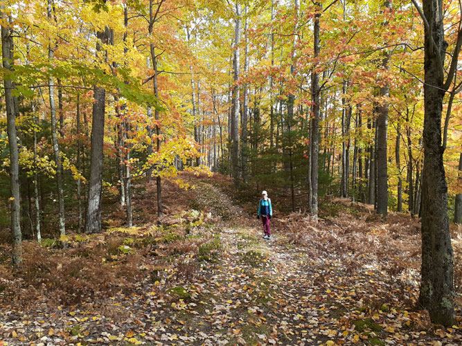
October 11, 2022 -- Rapid River Ski Trail
Beautiful 4 hour walk! The hills and valleys
as steep and fun as ever. Overcast but 60 degrees with reasonable
wind. Life is good in the northwoods.
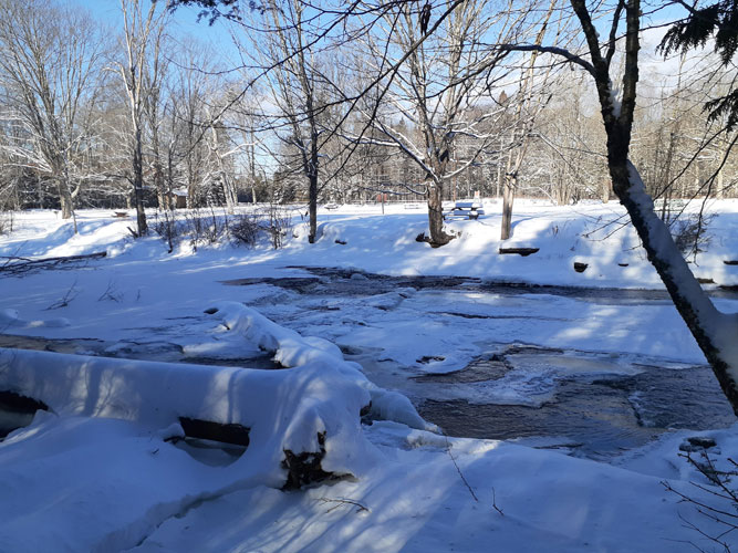
December 8, 2021 -- Checking Out the Snowshoe Trails
It was a bit chilly when we headed out this
morning (it had warmed up to zero by the time we left) but it was
clear skies and a forecast of calm and 24 degrees later. Steve had sold
one of his older fiddles (having bought a new one and running out of
places to store them) and had offered to deliver it to Trenary. We
wanted to get some cedar shavings from the Trenary Mill anyway (really great
fire starters!). We tossed in the snowshoes with plans to check out
a couple of snowshoe trails. The recent snowstorm had been pretty
widespread across the U.P. so snow and snowshoeing was pretty much
assured, starting from our front door.
Our business completed, our first stop was
the Rapid River Ski Trail. There was more snow here so not
surprising the ski trails looked in great shape and recently
groomed. And it had warmed up into the teens with clear sunny skies.
Now, the snowshoe trails get "groomed" by the first to walk them, and
that apparently was going to be us. So off we went into the soft
cold snow, trading off breaking trail as we went along, aware that
we were making track for whoever might come after (until there is
another big snow to cover up all tracks and it all begins again).
The first section is along a straight power
line opening but with some light hills. Part of it also shares with
the first ski loop so that was groomed. But there was room on
either side of the groomed tracks to stay off of them and was a nice
break from the deeper snow. Then the ski trail cut off and soon the
snowshoe trail turned into a beautiful but sometimes very wet low
lying woods. Thankfully it was a much drier year and enough snow
cover so only the first step looked damp, then all was well. It was
great to see nice new trail signs and markers since half of the
snowshoe loop is also the beginner/tot ski loop. Being assured of
where you are and that you are on the right path helps keep the
outing fun. Plus it shows the Trail is being well maintained
(kudos to Hiawatha National Forest staff and volunteers). At the top corner
of the loop we came to a new sign that pointed off on a side trail
that had been made through the woods down to the Rapid River Falls.
How nice! It's more river than falls this time of year but it was
flowing beautiful and musical,
and a real nice addition to the fairly short snowshoe loop.
Around to cross the A Loop of the ski trail we continued on the snow
covered two-track section, straight and true right down the middle
since this is part of the Tot Loop here and we wanted to make a nice
track for Tots of all ages. Back at the parking lot, well short
of an hour, we brushed off the snowshoes and put them back in the
car alongside the bale of aromatic cedar shavings. It was a short but sweet
walk (helped along by some Trenary Raisin Cinnamon bread!).
Now on to check out the Days River Snowshoe Trail and the nearby
Snowmobile Trail (see those pages for reports). ...
Our legs could feel the combined walks of the day, the longest yet
on snowshoes and in soft snow this season ... but we were
happy to be out on such a nice day. We knew that the coming forecast
of above freezing temperatures and chance of rain would likely keep
us off the trails for awhile.
Back at the garage we finished our snowshoeing adventures for the
day, with the final 1/2
mile walk down the hill and through our extremely beautiful woods
(in our opinion!) with enough light in the sky and a bright quarter
moon to guide us along our well packed trail. LilliB wasn't even
concerned about it being a little past dinner time, and the temperature was 5
degrees warmer than when we'd left in the cold this morning. Another beautiful
day.
November 1, 2021 -- Returning to the
Rapid River Cross Country Ski Trails
The significant ups and downs of the Rapid
River Trail was a perfect match to the significant ups and downs of
November weather, and a perfect start to the month, revisiting these
fun trails in a much dryer season than our last visit. It was cool
and breezy but we packed our hot drinks and hot lunch (getting our
little Funtainers thermoses out for the new hiking season) and as
soon as it warmed up a bit we headed out for the day.
 These
trails are just plain a lot of fun, and we thoroughly enjoyed
trekking through this beautiful area. We chose to go the skating
loops (S1, S2) since they are wider and allow side-by-side walking.
But they certainly aren't stingy in the generous ascents and
descents! The cloud cover broke up during the day and we enjoyed he
warmth and cheer of partial sunshine.
These
trails are just plain a lot of fun, and we thoroughly enjoyed
trekking through this beautiful area. We chose to go the skating
loops (S1, S2) since they are wider and allow side-by-side walking.
But they certainly aren't stingy in the generous ascents and
descents! The cloud cover broke up during the day and we enjoyed he
warmth and cheer of partial sunshine.
As we expected, it was much drier than our
previous hikes (it had been a particularly dry summer/early fall)
and there was no standing water in the bogs. But we didn't have any
trouble recognizing the bog pond at the bottom of steep sandy
Geronimo Hill that we had wetly traversed last spring. Though the
bog was dry the former pond across the trail was still damp enough
to warrant careful walking along the edge.
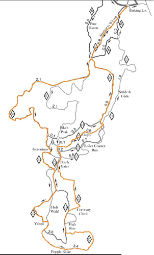
At the south section we decided to go the
longer D route this time instead of S2. But some of the D parts were
fenced off (as they were the last time we were here). We walked
around one barrier to find out why -- it went down into a marshy
spot that even now was wet. OK. Back we went to take the S2
alternate, missing out on 'Holy Wah!' but getting to experience
'Yahoo!'. They have a good time naming the steepest hills! Back on D
we got to do the most southerly 'Popple Ridge' section, and it was a
shining big gem of a highlight on an already incredible series of
high end hiking. A very high beautiful ridge walk that gives view
across the wide (Rapid River?) valley to the cliffs of Stonington
Peninsula. And an appropriately placed bench to rest with the vista.
Wow. But we were only half way around so off we went to continue our
hike up the east side of the loops.
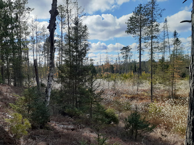
As we came off of the ridge we were
surprised to see a beautiful expanse of dry marsh down in the valley
that looked to be full of soft flowering plants. Turns out they were
mature blossoms ready (I'm guessing) to send their seeds out like
small dandelion feathers. One of so many special views on our
equally enjoyable second half. When we got back to the car, after
about 3 hrs on the trail, we were happy to sit down but also happy
to be feeling good. We figured we'd gone about 9 miles and that was
plenty in this hilly terrain for a hike so early in the season.
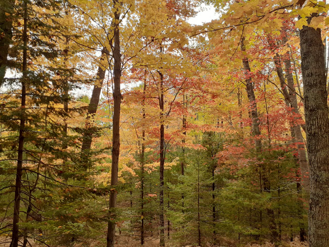
April 25, 2021 -- Walking the Skating Loops
With a stretch of rain/snow/sleet days forecast
(you have to love the diversity of spring weather!) today was the last
day to get in a hike before those indoor days started. We'd had a number
of decent outdoor homestead work days which felt good so were in the
mood to take the day off for a hike. The whole Bruno's Run trail had
been in our minds but when the day arrived with temps in the 30's and a
very brisk north wind we decided to save that for a nicer more leisurely
day. When we'd been on the Rapid River Ski Trail in December it had been
well wooded with wind-blocking conifers, just right for this day, so
back to that trail we would go. It was sunny but still cool in the
morning so we did a bit of shopping in Escanaba while the day warmed up
some. It wasn't exactly warm at about 40 degrees but that was a lot
warmer than our previous trip here and we now had our clothing systems
pretty well worked out. The trick is to wear enough to be warm at the
start (or the end if you are still out when the sun and the temperatures
go down) yet have enough room in your pack to stuff in jackets, mitten,
hats when it warms up. We had both sun and hill climbs to warm us and
gusty north wind to keep us cool. What more could one ask for!
We had done the very nice B Loop last time so decided to check out
the Ski Skating Loops this time. We knew there would be some low
spots but hoped the wider skating loops might allow for easier walk-arounds.
Plus it would be side-by-side walking most of the way which we
enjoy. We'd had a bit of snow on the ground at home and there was
some here, too, but it was minor. So we headed out on purple Easy
Loop A (a nice gentle way to start and end a hike) to get to red
Skating Loop S1which was in the same central section as our previous
walk. The terrain was similar with beautiful conifer woods and hilly
sandy high ridges amongst the bright green wetlands swamps and
lowlands. This section is designated "moderate" but they are not
overstating the ups and down with their loopy symbol. One minute
you'd be looking down, down at the low area below, then the next you
are down there looking up. As the sun was mostly overhead and the
trees mostly blocking the bulk of the wind we ended up with cold
weather jackets in our packs and much modifying of other layers. It
really was a beautiful day for a hike and a beautiful area. We did
run across, or I should say "very carefully skirted" a few wet
sections but got by with only minor wet feet. The bogs were wet and
well thawed now.
At the junction area of the central S1-B (red and gold) and S2-D
southern (green and blue) trails we headed into new territory onto
Skating Loop 2. We were surprised to meet a bicyclist since this
isn't much of a biking trail with the steep and very sandy hills.
But she said she had skied the area so was familiar with it, and she
walked the steepest grades. Even the central area isn't for casual
walkers but this farthest section has a "most difficult" jaggy
peaked up/down sign, and the various hills have names such as
Yahoo!, Holy Wah!, High Rise, Coronary Climb. And they aren't
exaggerating! The ridges are high and the wetlands low, and wet, and
beautiful. We refrained from taking more photos of the bogs (see
Days River hikes) but did try to take one looking down into the
lowlands from a ridge, but it is hard to get the scale in a photo.
The best thing is for you to walk it and see for yourself. Well
worth it!
The bicyclist had gone on ahead of
us but soon we met her coming back. She said there was a wet part up
ahead that she didn't think she could ride her bike through but
maybe we could find a way around. And sure enough, a short ways
ahead we found ourselves at the top of a steep sandy slope down to a
nice little pond at the bottom, with generous wet bogs on either
side. Definitely a "wet" patch. Mmmm. Well, we'd traversed wetlands
before so down we went, heels dug into the soft sand, to where the
trail disappeared into the water. It didn't look too promising, wet
bog moss as far as we could see, but maybe some of those hummocks
and bumps in the bog were solid. I went first (Steve's big on
sending the light-weight canary first). Nope, not solid. That one
either. There's a tree mound - very slippery, and wet. So I
continued, stepping carefully, looking for possible dry footing
though my feet were definitely not dry by now, going for the
shallowest wet, hanging on to the small conifers trying not to slip
into something deeper. I made it to the other side to find Steve
still at beginning, doing something. He was teetering on a
high (relatively speaking) mound taking off his shoes and socks.
Then he made his way around barefoot on (or rather, in) the squishy
carpet of beautiful moss. This worked pretty good until the end when
what looked like a shallow area almost to the dry trail turned out
to be a calf deep bog moss covered little pond. Oh well. So he ended
up with his dry shoes and socks that he was carrying but very wet
pants and long-johns. I had wet shoes and socks but dry pants, being
a bit luckier in my choices of foot-falls.
The trail went up from there on dry land so
we laughed, I took off my shoes and socks and joined Steve walking
barefoot for awhile, enjoying the warm soft sand and pine needle
covered path as our feet dried. Then taking a break in the sun Steve
put his shoes and socks back on and I went sockless in my wet shoes
for awhile so the footbeds could dry a bit before putting on dry
socks (we both carry dry socks in our packs), hanging my wet wool
socks on the back of my pack. We were glad the weather was mild, and
grateful neither of us had fallen full in the bog. We decided next
time the time-honored solution for crossing creeks and streams of
taking socks off, shoes on, pants rolled up would work better. And
we appreciated quick drying synthetic hiking clothes and shoes. We
were sorry we hadn't taken a photo of that scenic spot but we
weren't going back to do so.
On around S2 we went, or rather up and down
we went. It felt good to be out doing something we enjoy and feeling
good physically. There came on one bog spot that the trail workers
had dug the ground from beside the path, piling it on and raising
the trail above water level and on top of a culvert. It was rough
and messy yet but very much appreciated. It's not easy to turn a ski
trail into a non-snow hiking path through this terrain and we're
happy they are doing so. It's such a great place to walk.
After the steep hills of the southern part, then the moderate
(relatively speaking) central section, we were back to the Easy A
Loop, enjoying the wind-down walk. The sun was going lower and the
temperature falling a bit but the wind had been wonderfully moderate
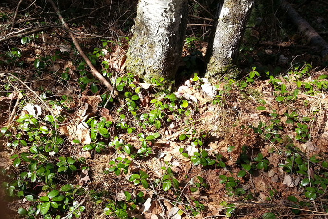
on the ground amongst the trees. We especially noticed the plentiful
Wintergreen ground cover here, seen throughout the entire area, the
smooth leaves shining so bright among the dried pine needles and
leaves. It was an eight and half mile walk, more vertical than
horizontal, and a thoroughly enjoyable less than 4 hour hike. And we
still have D Loop to look forward to, once it has dried out some.
One more thing that makes this a special ski and hiking trail system
is the absence of logging. The area is full of impressive large
conifers and the lack of logging has allowed the area to settle into
a healthy and natural setting. I don't know the history of the area,
when the Ski Trail was established or how long it has been since it
was logged but it has been awhile. It sure would be nice if the DNR
would follow this example at Days River. Meantime, we're happy for
what is offered there but doubly impressed with the Forest Service
leaving this area free to be while maintaining the trails.
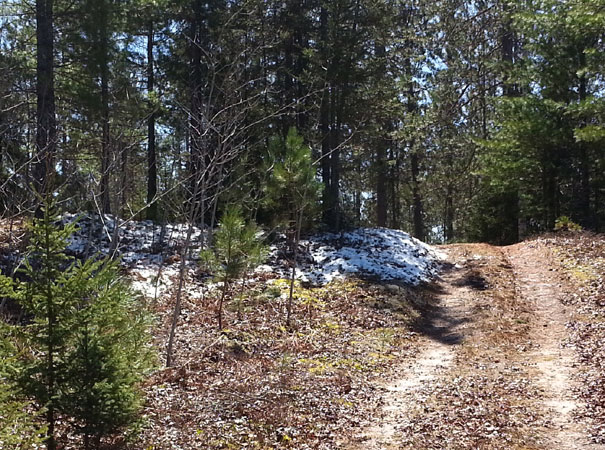
December
15, 2020 -- A New Day, A New Trail
It just keeps happening - another good day to go
for a hike. A little colder than the last one but not too much, 23 to
begin with and calm, partly sunny (hurray!) and it warmed up a few
degrees later on. No new snow. Might as well check out another ski
trail. This
 time
the Rapid River National Cross Country Ski Trail. We don't know what
makes it national but we know it's very popular with skiing friends. And
we found it to be yet another great hiking destination, about 40 miles
from home.
time
the Rapid River National Cross Country Ski Trail. We don't know what
makes it national but we know it's very popular with skiing friends. And
we found it to be yet another great hiking destination, about 40 miles
from home.
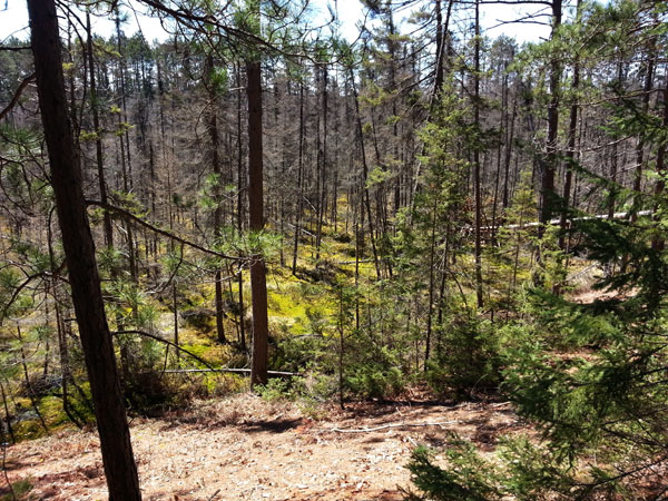
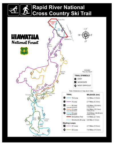
The Loop B we took (the gold one) is almost
entirely in conifer forest - Red Pine, Balsam Fir, Hemlock, some Spruce,
occasional Cedar. Designated "moderate difficulty" for skiing it makes
its way, with appropriate ups and downs, along an surprisingly high, then
very high, ridge. One certainly wouldn't want to accidentally ski off
the trail down the sides (which isn't likely considering the generous
number of trees). The trail does head on down to the low bogs/swamps now
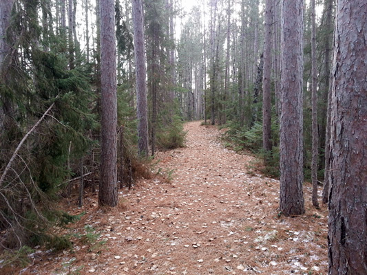
and then, but mostly it's high above on a beautifully maintained (by
those ever busy volunteers) pine needle strewn trail, looking down on
(now frozen) wetlands. There are sections along old and current
two-tracks but that just makes for a nice change for side-by-side
walking.
 Most trail walking is single file so we change
off about every half hour, with a quick (or longer) stop for drinks and
snacks, and midway usually a longer one for more substantial food. We
finished the loop and were back in the parking lot sooner than we thought. So still with energy left and daylight (we got on the
trail earlier this time) we took in a second smaller "snowshoe" loop.
Flatter and calmer (most of it is also the "Tot Loop" and follows partly
straight along a pipeline clearing) this was a good way to end the hike.
Seven miles and less than 3 hours we were back in the car finishing up
our lunch (we find it hard to take very much time to eat on the trail
when it's cold, no matter how scenic it is). This will be another good
trail to return to in the future, with more loops to explore as well, as
long as the snow holds off. But when it does arrive (making very happy
skiers!) it will be there waiting for us hikers next year.
Most trail walking is single file so we change
off about every half hour, with a quick (or longer) stop for drinks and
snacks, and midway usually a longer one for more substantial food. We
finished the loop and were back in the parking lot sooner than we thought. So still with energy left and daylight (we got on the
trail earlier this time) we took in a second smaller "snowshoe" loop.
Flatter and calmer (most of it is also the "Tot Loop" and follows partly
straight along a pipeline clearing) this was a good way to end the hike.
Seven miles and less than 3 hours we were back in the car finishing up
our lunch (we find it hard to take very much time to eat on the trail
when it's cold, no matter how scenic it is). This will be another good
trail to return to in the future, with more loops to explore as well, as
long as the snow holds off. But when it does arrive (making very happy
skiers!) it will be there waiting for us hikers next year.
The one issue we're still challenged by is
keeping our hands warm. We're still working on a good layering system.
One that will keep those important fingers happy yet allow some
dexterity. In cold temperatures one isn't very inclined to pull hands
out of cozy cocoons for even quick chores. But with each trip we come
back with ideas -- gives us something to work on during the non-hiking
days! Fine-tuning the gear seems to be a big
part of the fun.
* * * * * *
Copyright
© Susan Robishaw and Stephen Schmeck